Category:Kimberley, Nottinghamshire
Jump to navigation
Jump to search
Brezhoneg: Kimberley zo ur gêr e Nottinghamshire, e Bro-Saoz. Gwechall e oa brudet glaou ha bier Kimberley, aet holl da get hiziv.
English: Kimberley is a town in Nottinghamshire, England, lying 6 miles northwest of Nottingham along the A610. The town grew as a centre for coal mining, brewing and hosiery manufacturing. Together with the neighbouring villages of Giltbrook and Greasley, it has a population of around 6,500 people.
Français : Kimberley est une ville du comté de Nottinghamshire, en Angleterre, naguère célèbre pour ses mines de charbon et sa brasserie, aujourd'hui fermées.
Nederlands: Kimberley is een plaats in het bestuurlijke gebied Broxtowe, in het Engelse graafschap Nottinghamshire. De plaats telt 6.849 inwoners.
Română: Kimberley este un oraş în comitatul Nottinghamshire, regiunea East Midlands, Anglia. Oraşul se află în districtul Broxtowe.
town in Nottinghamshire, England  Y Gofgolofn Ryfel, Kimberley | |||||
| Upload media | |||||
| Instance of | |||||
|---|---|---|---|---|---|
| Location | Broxtowe, Nottinghamshire, East Midlands, England | ||||
| Said to be the same as | Kimberley (Wikimedia duplicated page, civil parish) | ||||
 | |||||
Subcategories
This category has the following 5 subcategories, out of 5 total.
H
K
T
Media in category "Kimberley, Nottinghamshire"
The following 200 files are in this category, out of 226 total.
(previous page) (next page)-
 Kimberley (geograph 5707397).jpg 851 × 1,280; 537 KB
-
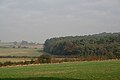
 A view into Derbyshire - geograph.org.uk - 5043136.jpg 1,024 × 768; 950 KB
-
 A610 East off Swingate Bridge - geograph.org.uk - 1978227.jpg 640 × 480; 195 KB
-
 A610 near Giltbrook - geograph.org.uk - 1810749.jpg 640 × 480; 56 KB
-
 A610 West off Swingate Bridge - geograph.org.uk - 1978221.jpg 640 × 480; 224 KB
-
 Across Kimberley Cricket Ground - geograph.org.uk - 5531479.jpg 1,024 × 768; 783 KB
-
 Across the Erewash Valley - geograph.org.uk - 5825583.jpg 1,024 × 768; 974 KB
-
 Approaching Junction 26 on the M1 - geograph.org.uk - 2843102.jpg 640 × 480; 48 KB
-
 At Grasscroft Farm - geograph.org.uk - 5825442.jpg 1,024 × 732; 814 KB
-
 Babbington Lane on a summer evening - geograph.org.uk - 5042855.jpg 1,024 × 768; 1,016 KB
-
 Babbington Lane, footpath fingerposts - geograph.org.uk - 5825409.jpg 1,024 × 768; 818 KB
-
 Babbington Lane, Swingate - geograph.org.uk - 3746768.jpg 1,024 × 768; 110 KB
-
 Babbington to Swingate - geograph.org.uk - 5531856.jpg 1,024 × 768; 945 KB
-
 Babbington Village - geograph.org.uk - 5531846.jpg 1,024 × 768; 1,011 KB
-
 Babbington, barns on Westby Lane - geograph.org.uk - 5825373.jpg 1,024 × 732; 753 KB
-
 Babbington, nearing The Gate House - geograph.org.uk - 5043157.jpg 1,024 × 1,024; 1.45 MB
-
 Babbington, The Gatehouse - geograph.org.uk - 5825394.jpg 819 × 1,024; 1.12 MB
-
 Bales at Grasscroft Farm - geograph.org.uk - 5042890.jpg 1,024 × 682; 824 KB
-
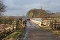
 Bridge over the A610 - geograph.org.uk - 1810751.jpg 640 × 480; 88 KB
-
 Bridleway near Turkey Farm - geograph.org.uk - 604252.jpg 640 × 427; 126 KB
-
 Car park furniture - geograph.org.uk - 619847.jpg 640 × 427; 94 KB
-
 Cattle at Babbington - geograph.org.uk - 5531849.jpg 1,024 × 768; 871 KB
-
 Chapel and tree, Kimberley cemetery - geograph.org.uk - 2158835.jpg 640 × 480; 50 KB
-
 Cricketers Rest.JPG 1,280 × 960; 236 KB
-
 Cycling from Babbington - geograph.org.uk - 5043159.jpg 1,024 × 732; 1 MB
-
 Down the hill to Babbington Village - geograph.org.uk - 5531837.jpg 1,024 × 768; 972 KB
-
 Eastwood Road (West) in Giltbrook - geograph.org.uk - 6298459.jpg 1,024 × 757; 131 KB
-
 Eastwood Road, Kimberley - geograph.org.uk - 5705021.jpg 1,280 × 851; 440 KB
-
 Farmland near Babbington - geograph.org.uk - 6298425.jpg 1,024 × 768; 209 KB
-
 Footbridge over the A610 - geograph.org.uk - 1810753.jpg 640 × 480; 65 KB
-
 Footpath through the trees to Kimberley - geograph.org.uk - 4859662.jpg 1,024 × 768; 410 KB
-
 Footpath to Awsworth - geograph.org.uk - 5825402.jpg 1,024 × 768; 967 KB
-
 Footpath, Nuthall to Kimberley - geograph.org.uk - 2158574.jpg 640 × 480; 63 KB
-
 Framing the view - geograph.org.uk - 611626.jpg 640 × 427; 112 KB
-
 Gate Inn.JPG 1,280 × 960; 217 KB
-
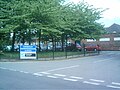
 Gilthill Primary School, Kimberley - geograph.org.uk - 942505.jpg 640 × 480; 55 KB
-
 Grasscroft Farm, black plastic at sundown - geograph.org.uk - 5042879.jpg 1,024 × 768; 760 KB
-
 Great Northern Railway Path - geograph.org.uk - 5707600.jpg 1,280 × 851; 697 KB
-
 Great Northern Railway Path - geograph.org.uk - 5708053.jpg 1,280 × 851; 639 KB
-
 Hall Om Wong 'Open Space', Kimberley - geograph.org.uk - 1095179.jpg 640 × 480; 117 KB
-
 Hall Om Wong Open Space - geograph.org.uk - 4186473.jpg 640 × 480; 122 KB
-
 Houses on Swingate - geograph.org.uk - 3746789.jpg 1,024 × 768; 104 KB
-
 James Street, Kimberley - geograph.org.uk - 1098425.jpg 640 × 480; 91 KB
-
 Dillinger's Bar and Diner, Kimberley, Nottinghamshire.jpg 640 × 480; 71 KB
-
 Kimberley Brewery - undergoing redevelopment - geograph.org.uk - 5708046.jpg 851 × 1,280; 584 KB
-
 Kimberley Brewery Yard - geograph.org.uk - 5531747.jpg 800 × 800; 793 KB
-
 Kimberley Bridge - Midland Railway Bridge 13 - geograph.org.uk - 2059884.jpg 2,816 × 2,112; 2.71 MB
-
 Kimberley Caravan Centre - geograph.org.uk - 6238605.jpg 4,000 × 3,000; 2.42 MB
-
 Kimberley Cemetery (2) - geograph.org.uk - 942722.jpg 640 × 480; 53 KB
-
 Kimberley cemetery - geograph.org.uk - 2158846.jpg 640 × 480; 54 KB
-
 Kimberley Cemetery - geograph.org.uk - 942716.jpg 640 × 480; 63 KB
-
 Kimberley cemetery and chapel - geograph.org.uk - 2158719.jpg 640 × 480; 54 KB
-
 Kimberley cemetery and chapel - geograph.org.uk - 2158842.jpg 480 × 640; 47 KB
-
 Kimberley cemetery chapel - geograph.org.uk - 2158839.jpg 640 × 480; 46 KB
-
 Kimberley Chapel - geograph.org.uk - 2026759.jpg 640 × 480; 205 KB
-
 Kimberley Chapel of Rest Small.jpg 1,288 × 966; 227 KB
-
 Kimberley Church - geograph.org.uk - 5707261.jpg 851 × 1,280; 525 KB
-
 Kimberley Fish Chips.JPG 1,280 × 960; 274 KB
-
 Kimberley from the cemetery - geograph.org.uk - 2158749.jpg 640 × 480; 63 KB
-
 Kimberley from the cemetery - geograph.org.uk - 2158814.jpg 640 × 480; 74 KB
-
 Kimberley Institute Cricket Ground - geograph.org.uk - 5531457.jpg 1,024 × 768; 823 KB
-
 Kimberley keystone - geograph.org.uk - 5565821.jpg 768 × 1,024; 970 KB
-
 Kimberley Midland Railway Station - geograph.org.uk - 6251163.jpg 4,896 × 3,672; 6.84 MB
-
 Kimberley Miners Welfare - geograph.org.uk - 942510.jpg 640 × 480; 55 KB
-
 Kimberley Post Office.JPG 1,280 × 960; 281 KB
-
 Kimberley School - geograph.org.uk - 5704949.jpg 1,280 × 851; 555 KB
-
 Kimberley Water Tower, Nottinghamshire.JPG 1,932 × 2,576; 1.11 MB
-
 Kimberley, A Plumb ^ Son - geograph.org.uk - 5025497.jpg 768 × 1,024; 1.04 MB
-
 Kimberley, a summer evening in Main Street - geograph.org.uk - 5025487.jpg 1,024 × 682; 811 KB
-
 Kimberley, Chapter Drive and the Cemetery - geograph.org.uk - 5825607.jpg 1,024 × 732; 828 KB
-
 Kimberley, Clinton Terrace - geograph.org.uk - 5531662.jpg 1,024 × 1,024; 1.15 MB
-
 Kimberley, former Methodist Church - geograph.org.uk - 5833125.jpg 1,024 × 819; 1,007 KB
-

-
 Kimberley, High Street - geograph.org.uk - 5825644.jpg 1,024 × 731; 1,011 KB
-
 Kimberley, Main Street - geograph.org.uk - 5825647.jpg 819 × 1,024; 958 KB
-
 Kimberley, Station Road and a view of the brewery - geograph.org.uk - 5531546.jpg 1,024 × 1,024; 1.18 MB
-
 Kimberley, support for England at the World Cup - geograph.org.uk - 5825646.jpg 819 × 1,024; 868 KB
-
 Kimberley, the Cricketers' Rest - geograph.org.uk - 5531780.jpg 1,024 × 1,024; 1.22 MB
-
 Kimberley, up James Street - geograph.org.uk - 5825645.jpg 819 × 1,024; 980 KB
-
 KimberleyComp.JPG 1,280 × 960; 301 KB
-
 Knowle Lane, Swingate - geograph.org.uk - 3746744.jpg 1,024 × 768; 107 KB
-

-
 Lord Clyde - geograph.org.uk - 6165804.jpg 3,283 × 2,648; 1.1 MB
-
 M1, southbound - geograph.org.uk - 4682154.jpg 640 × 274; 19 KB
-
 Main Street, Kimberley - geograph.org.uk - 84338.jpg 640 × 432; 100 KB
-
 Maintenance access onto the motorway - geograph.org.uk - 604279.jpg 480 × 640; 117 KB
-
 Manor Farmhouse, Kimberley.jpg 1,024 × 732; 1.09 MB
-
 Marie says nearly home - geograph.org.uk - 611635.jpg 640 × 427; 76 KB
-
 Maws Lane Co-op, Kimberley - geograph.org.uk - 5704547.jpg 1,280 × 872; 388 KB
-
 Maws Lane in Kimberley - geograph.org.uk - 6298452.jpg 640 × 487; 81 KB
-
 Maws Lane, Kimberley - geograph.org.uk - 1831140.jpg 640 × 480; 99 KB
-
 Maws Lane, Kimberley - geograph.org.uk - 5704556.jpg 1,280 × 851; 497 KB
-
 Maws Lane, Kimberley - geograph.org.uk - 942517.jpg 640 × 480; 80 KB
-

-
 Midland Railway route entering Kimberley - geograph.org.uk - 2059910.jpg 2,816 × 2,112; 4.88 MB
-
 Muckraking - geograph.org.uk - 617035.jpg 640 × 466; 38 KB
-
 Mud - geograph.org.uk - 607903.jpg 640 × 427; 127 KB
-
 Near Babbington - geograph.org.uk - 5043144.jpg 1,024 × 768; 973 KB
-
 Near Grasscroft Farm - geograph.org.uk - 5531882.jpg 1,024 × 768; 891 KB
-
 Near Grasscroft Farm - geograph.org.uk - 6298439.jpg 1,024 × 768; 359 KB
-
 Near the south end of Swingate - geograph.org.uk - 3746763.jpg 1,024 × 768; 136 KB
-
 Near Turkey Fields Farm, Strelley - geograph.org.uk - 15808.jpg 640 × 423; 61 KB
-
 Nelson and Railway, Kimberley - geograph.org.uk - 536898.jpg 640 × 480; 115 KB
-
 Newdigate Street, Kimberley - geograph.org.uk - 5704796.jpg 1,280 × 851; 457 KB
-
 On Westby Lane - geograph.org.uk - 5043170.jpg 1,024 × 732; 928 KB
-
 Path to Babbington - geograph.org.uk - 5042851.jpg 1,024 × 768; 1,019 KB
-
 Playground at Hall Om Wong Open Space - geograph.org.uk - 6238604.jpg 4,000 × 3,000; 2.83 MB
-
 Playground, Kimberley - geograph.org.uk - 2963718.jpg 800 × 600; 173 KB
-
 Playing fields, Swingate - geograph.org.uk - 616566.jpg 640 × 466; 37 KB
-

-
 Public footpath north of Grasscroft Farm - geograph.org.uk - 4859656.jpg 1,024 × 768; 257 KB
-
 Retail park, Kimberley - geograph.org.uk - 2708349.jpg 1,600 × 1,200; 367 KB
-
 South end of Clive Crescent, Swingate - geograph.org.uk - 3746727.jpg 1,024 × 768; 102 KB
-
 South from Grasscroft Farm - geograph.org.uk - 5042868.jpg 1,024 × 768; 837 KB
-

-
 Swingate Reservoir and Water Tower - geograph.org.uk - 5025636.jpg 1,024 × 768; 1.11 MB
-
 Swingate to Ratcliffe on Soar - geograph.org.uk - 5025597.jpg 1,024 × 768; 1.01 MB
-
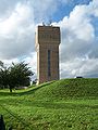
 Swingate Water Tower - geograph.org.uk - 5531886.jpg 768 × 1,024; 977 KB
-
 Swingate Water Tower.jpg 2,241 × 3,472; 1.5 MB
-
 Swingate, Babbington Lane and Swingate Water Tower - geograph.org.uk - 5025650.jpg 1,024 × 768; 1.03 MB
-
 Swingate, barley at Spring Hill - geograph.org.uk - 5825595.jpg 1,024 × 768; 832 KB
-
 Swingate, evening sunlight - geograph.org.uk - 5025794.jpg 1,024 × 732; 1,022 KB
-
 Swingate, footpath and barley field - geograph.org.uk - 5825588.jpg 1,024 × 768; 981 KB
-
 Swingate, footpath to Little Lane - geograph.org.uk - 5025639.jpg 1,024 × 768; 1.07 MB
-
 Swingate, once The Queen Adelaide - geograph.org.uk - 5025674.jpg 1,024 × 732; 1.05 MB
-
 Swingate, rooftops and transmitter - geograph.org.uk - 5031039.jpg 1,024 × 768; 1.07 MB
-
 Swingate, south from Babington Lane - geograph.org.uk - 5025586.jpg 1,024 × 768; 1,015 KB
-
 Swingate, Spring Hill - geograph.org.uk - 5825600.jpg 1,024 × 1,024; 1.09 MB
-
 Swingate, the former Queen Adelaide - geograph.org.uk - 5042843.jpg 1,024 × 683; 831 KB
-
 Swingate, The White Lion - geograph.org.uk - 5025574.jpg 1,024 × 878; 1.01 MB
-
 Swingate, up Little Lane - geograph.org.uk - 5025507.jpg 1,024 × 1,024; 1.15 MB
-
 Swingate, up Little Lane - geograph.org.uk - 5833132.jpg 1,024 × 1,024; 1.22 MB
-
 Swingate, West Street - geograph.org.uk - 5025511.jpg 1,024 × 1,024; 1.2 MB
-

-
 The Maltings, Hardy and Hanson's Brewery.jpg 1,024 × 1,024; 1.17 MB
-

-
 The southern edge of Swingate - geograph.org.uk - 5025802.jpg 1,024 × 1,024; 1.14 MB
-
 The White Lion, Swingate - geograph.org.uk - 3746754.jpg 1,024 × 768; 137 KB
-
 Three counties from Grasscroft Farm - geograph.org.uk - 5825440.jpg 1,024 × 732; 801 KB
-
 Towards Ilkeston - geograph.org.uk - 5043164.jpg 1,024 × 731; 894 KB
-
 Track to Grasscroft Farm - geograph.org.uk - 4859646.jpg 1,024 × 768; 172 KB
-
 Tree, Kimberley cemetery - geograph.org.uk - 2158819.jpg 640 × 480; 49 KB
-
 UK Roundabout Sign - geograph.org.uk - 5161274.jpg 1,600 × 1,200; 188 KB
-

-
 Up the lane to Grasscroft Farm - geograph.org.uk - 5043147.jpg 819 × 1,024; 1.11 MB
-
 View from Kimberley Chapel - geograph.org.uk - 2026758.jpg 640 × 480; 223 KB
-
 View of footbridge over A610 from Swingate bridge - geograph.org.uk - 5158568.jpg 4,896 × 3,672; 6.33 MB
-
 Water Tower Swingate - geograph.org.uk - 1978250.jpg 640 × 480; 192 KB
-
 Woodland Close, Watnall - geograph.org.uk - 2475063.jpg 640 × 480; 124 KB
-
 Woodland Footpath, Kimberley - geograph.org.uk - 2963698.jpg 800 × 600; 212 KB
-
 A choice of styles - geograph.org.uk - 616496.jpg 640 × 466; 95 KB
-
 A corner of Spring Wood - geograph.org.uk - 607172.jpg 640 × 427; 66 KB
-
 A corner of Strelley Hall park - geograph.org.uk - 604287.jpg 640 × 480; 70 KB
-
 Across the M1 - geograph.org.uk - 604271.jpg 640 × 480; 110 KB
-
 Autumn leaves near Turkey Farm - geograph.org.uk - 604254.jpg 427 × 640; 136 KB
-
 Babbington Lane - geograph.org.uk - 616595.jpg 466 × 640; 72 KB
-
 Bilborough College - geograph.org.uk - 487377.jpg 640 × 480; 43 KB
-
 Bridge over the motorway - geograph.org.uk - 659826.jpg 640 × 427; 102 KB
-
 Bridlepath Cottage - geograph.org.uk - 604277.jpg 640 × 480; 135 KB
-
 Bridleway and gate - geograph.org.uk - 607164.jpg 640 × 427; 167 KB
-
 Bridleway and stile near Turkey Farm - geograph.org.uk - 604255.jpg 427 × 640; 142 KB
-
 Bridleway from Swingate to Babbington - geograph.org.uk - 616502.jpg 640 × 466; 57 KB
-
 Broad Oak, Strelley - geograph.org.uk - 15108.jpg 640 × 425; 104 KB
-
 Catstone Hill - geograph.org.uk - 612356.jpg 640 × 427; 78 KB
-
 Catstone Hill - geograph.org.uk - 660500.jpg 640 × 427; 109 KB
-
 Coming to say hello - geograph.org.uk - 604280.jpg 480 × 640; 115 KB
-
 Countryside below Catstone Hill - geograph.org.uk - 612367.jpg 640 × 427; 85 KB
-
 Countryside near Babbington - geograph.org.uk - 616497.jpg 640 × 466; 59 KB
-
 Countryside near Babbington - geograph.org.uk - 616591.jpg 466 × 640; 55 KB
-
 Countryside near Swingate - geograph.org.uk - 616516.jpg 640 × 466; 67 KB
-
 Cow and Gate - geograph.org.uk - 616495.jpg 640 × 466; 96 KB
-
 Cricketers Rest, Kimberley - geograph.org.uk - 536900.jpg 480 × 640; 133 KB
-
 Derelict barn at Grasscroft Farm - geograph.org.uk - 616586.jpg 640 × 466; 73 KB
-
 Diverted footpath - geograph.org.uk - 616614.jpg 466 × 640; 77 KB
-
 Diverted right of way - geograph.org.uk - 611623.jpg 640 × 427; 115 KB
-
 Duckpond at Windmill Farm - geograph.org.uk - 617032.jpg 640 × 466; 77 KB
-
 Footpath at Chilwell Dam - geograph.org.uk - 617048.jpg 466 × 640; 91 KB
-
 Footpath from Swingate to Kimberley - geograph.org.uk - 616520.jpg 466 × 640; 55 KB
-
 Footpath signpost - geograph.org.uk - 616577.jpg 466 × 640; 97 KB
-
 Footpath Signpost near Swingate - geograph.org.uk - 616363.jpg 640 × 466; 57 KB
-
 From Swingate Hill - geograph.org.uk - 616579.jpg 640 × 466; 45 KB
-
 Gate Inn, Kimberley - geograph.org.uk - 536903.jpg 640 × 480; 79 KB
-
 Grasscroft Farm - geograph.org.uk - 616568.jpg 640 × 466; 54 KB
-
 Grasscroft Farm - geograph.org.uk - 616585.jpg 640 × 466; 62 KB
-
 Grasscroft Farm, near Swingate - geograph.org.uk - 616582.jpg 640 × 466; 42 KB
-
 Green and yellow - geograph.org.uk - 607165.jpg 427 × 640; 179 KB
-
 Hedgerow near Awsworth - geograph.org.uk - 607898.jpg 640 × 427; 182 KB
-
 Hump for half a mile - geograph.org.uk - 616358.jpg 466 × 640; 66 KB
-
 Lopsided tree - geograph.org.uk - 607169.jpg 640 × 427; 70 KB
-
 Misty Motorway (1) - geograph.org.uk - 604261.jpg 640 × 427; 51 KB
-
 Misty Motorway (2) - geograph.org.uk - 604263.jpg 640 × 427; 56 KB
-
 Motorway sign - geograph.org.uk - 617020.jpg 640 × 466; 47 KB
-
 New housing at Bilborough - geograph.org.uk - 667733.jpg 640 × 427; 71 KB
-
 No way past^ - geograph.org.uk - 611620.jpg 640 × 427; 126 KB
-
 Nottingham Business Park - geograph.org.uk - 612566.jpg 626 × 459; 56 KB
-
 Nottingham Business Park - geograph.org.uk - 612569.jpg 625 × 460; 94 KB
-
 Nottingham Business Park - geograph.org.uk - 612570.jpg 640 × 480; 58 KB
-

-
 Nottingham's highest point - geograph.org.uk - 616600.jpg 640 × 466; 43 KB
-
 Old Rectory Farm, Strelley - geograph.org.uk - 660392.jpg 640 × 427; 101 KB
.jpg)


_in_Giltbrook_-_geograph.org.uk_-_6298459.jpg)


_-_geograph.org.uk_-_942722.jpg)


,_Truman_Street,_Kimberley_-_geograph.org.uk_-_1095155.jpg)


_-_geograph.org.uk_-_604261.jpg)
_-_geograph.org.uk_-_604263.jpg)


